


Walks Around Reading
Click on the routes for details.
| Route Details | Distance | Interactive Map | Download GPX |
|---|---|---|---|
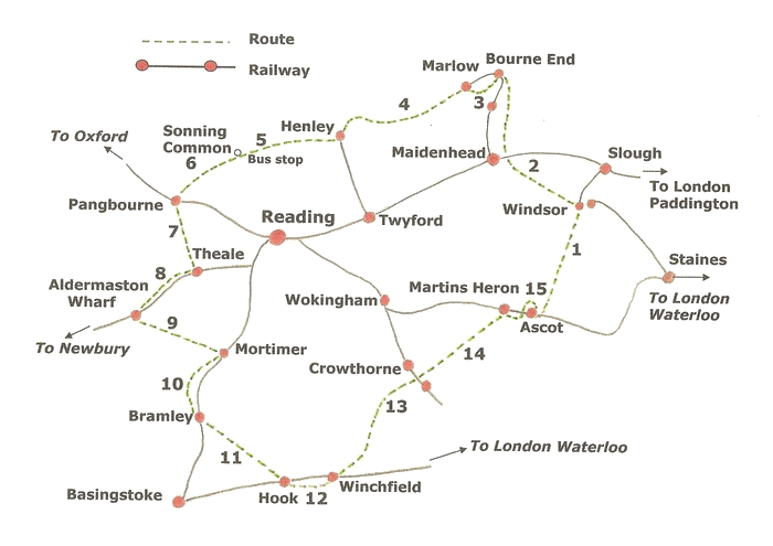
 Ascot to Windsor Ascot to Windsor | 8 miles | Walk 1 map | GPX file |
| An interesting walk on good paths following the route of the royal procession from Ascot through Windsor Great Park and offering a 'surprise' view of Windsor Castle. | |||
| Bourne End to Windsor | 11 miles | Walk 2 map | GPX file |
| Follow the Thames Path through the lovely scenery of Cliveden Reach. Visit Boulter's lock, enjoy the wildlife on the newly-created Jubilee River and pass close to Eton College. | |||
| Bourne End to Marlow | 5 miles | Walk 3 map | GPX file |
| An energetic walk with splendid views, through a picturesque village and ancient woodland. | |||
| Marlow to Henley | 8 miles | Walk 4 map | GPX file |
| A mainly level walk along the scenic Thames Path then rising to overlook the famous regatta course before descending to the much-photographed river bridge and church in Henley-on-Thames. | |||
| Sonning Common to Henley | 5.5 miles | Walk 5 map | GPX file |
| A varied walk passing through the lovely Chiltern countryside with its old churches in unspoiled villages, wooded slopes and glorious views. | |||
| Sonning Common to Pangbourne | 8 miles | Walk 6 map | GPX file |
| After passing through the shady woods and well-tended farms of the beautiful Chiltern Hills enjoy the extensive views over the Thames Valley, before descending to the twin villages of Whitchurch and Pangbourne. | |||
| Pangbourne to Theale | 5.5 miles | Walk 7 map | GPX file |
| A hilly walk from the River Thames through bluebell woods to the hospitable village of Theale in the Kennet Valley. | |||
| Aldermaston Wharf to Theale | 4.5 miles | Walk 8 map | GPX file |
| Enjoy the wildlife on this easy walk along the banks of the Kennet and Avon Canal. | |||
| Aldermaston Wharf to Mortimer | 8 miles | Walk 9 map | GPX file |
| Visit a restored Norman church harbouring the remains of a bloody battle, wander through tranquil woodland and enjoy fine views of both the Kennet and Loddon Valleys. | |||
| Mortimer to Bramley | 7 miles | Walk 10 map | GPX file |
| A walk into history. Visit the 12th century church of St Mary and explore the site of Calleva Atrebatum, once a main administrative centre for Roman Britain. | |||
| Bramley to Hook | 7 miles | Walk 11 map | GPX file |
| Water meadows, a water wheel, gently rolling countryside, shady copses and refreshment in a traditional English pub. | |||
| Hook to Winchfield | 7 miles | Walk 12 map | GPX file |
| This walk leads to the ruins of 13th century Odiham Castle and the upper reaches of the River Whitewater, then follows the towpath along the scenic Basingstoke Canal. | |||
| Crowthorne to Winchfield | 10 miles | Walk 13 map | GPX file |
| This walk is level at first alongside the Blackwater River then on higher ground through forest and heathland before descending to the Hart Valley. | |||
| Crowthorne to Martin's Heron | 8 miles | Walk 14 map | GPX file |
| Passing through the grounds of Wellington College and crossing ancient forest and heath to an iron age fort and a heritage centre, this walk has plenty of interest. | |||
| Martin's Heron to Ascot | 4.5 miles | Walk 15 map | GPX file |
| A level walk through Swinley Park, part of the Crown Estate, then across Ascot Heath with a close-up view of the world-famous race course. | |||