


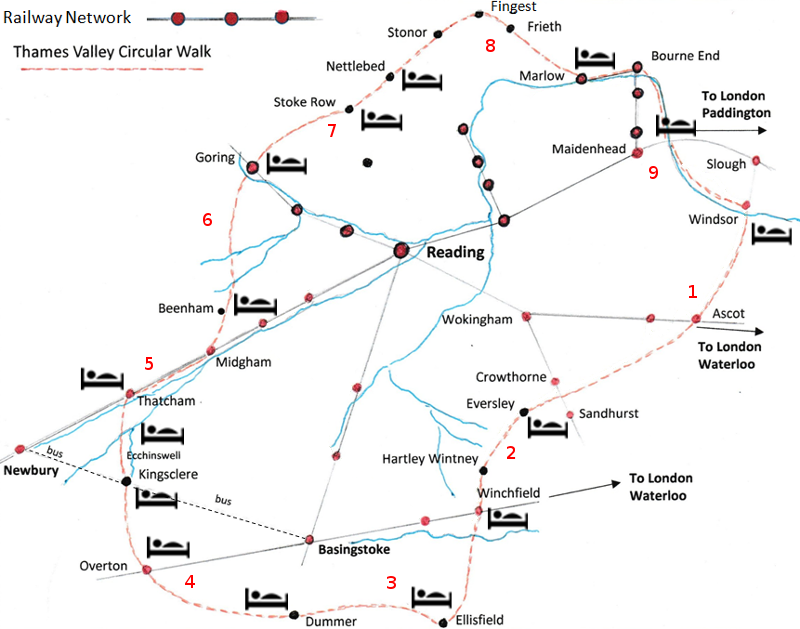
Thames Valley Circular Walk
Click the red arrows for details of the stages.
Click the beds for accommodation information.
Approximately 125 miles long, this circular long distance path has access points that are easily reached by train from London, Reading and adjoining stations. If time is limited it can be walked in sections at weekends and bank holidays with one or two overnight stops.
The walk passes through a variety of beautiful countryside including river valleys, chalk downland, coniferous forests, rare heath, and beech woods that are carpeted with bluebells in spring.
The Thames Valley Circular Walk is not way-marked although it sometimes shares rights of way with other long distance paths. The walk mostly follows footpaths and bridle-ways, linked together by quiet lanes.
Accommodation is available sporadically along the walk and at the end of each section. The farthest that needs to be covered in a day is about 12 miles. The terrain is not difficult although there are some steep, hilly sections, and care needs to be taken with map-reading in some places.
| Route Details | Distance | Interactive Map | Download GPX |
|---|---|---|---|
 Windsor to Sandhurst Windsor to Sandhurst | 16 miles | Stage 1 map | GPX file |
Windsor Castle and Deer Park  route of Queen's procession to Ascot Race Course an ancient pond in ancient heathland Royal forests a heritage centre a Roman Road Owlsmoor Bog and Edgebarrow Wood SSSI route of Queen's procession to Ascot Race Course an ancient pond in ancient heathland Royal forests a heritage centre a Roman Road Owlsmoor Bog and Edgebarrow Wood SSSI | |||
| Sandhurst to Winchfield | 10.5 miles | Stage 2 map | GPX file |
| river and lakes with nature reserve Charles Kingsley's church forest and heath stately oaks cricketers' pub historic church with a view | |||
| Winchfield to Dummer | 19 miles | Stage 3 map | GPX file |
| tranquil Norman church peaceful canal ruined castle colony of rare bats ancient tracks on chalk downs pretty hamlets far-reaching views | |||
| Dummer to Kingsclere | 14 miles | Stage 4 map | GPX file |
| royal dalliances corn fields birth of a river Roman road skylarks and cowslips renowned rabbit warren on high downland racehorse country | |||
| Kingsclere to Woolhampton | 11.5 miles | Stage 5 map | GPX file |
| water-meadows and snowdrops a village pond a peaceful common, once a place of conflict a restored canal | |||
| Woolhampton to Streatley | 13 miles | Stage 6 map | GPX file |
| canal boats country churchyard wolves! how Tutts Clump got its name blue pools and watercress beds bluebells and lambs ancient earthworks rare chalk downland with impressive views | |||
| Streatley to Stonor | 14.5 miles | Stage 7 map | GPX file |
| the Goring Gap oldest road charcoal burning beech woods and bluebells a Maharajah's well bangers and mash red kites a nature reserve | |||
| Stonor to Marlow | 11.5 miles | Stage 8 map | GPX file |
| stately home and deer park a windmill and a well-known vicar more red kites Chiltern villages and hospitality scenic views a regatta town | |||
| Marlow to Windsor | 14.5 miles | Stage 9 map | GPX file |
| boating on the Thames ancient wetlands area an historic village with artistic connections beautiful Clivedon Reach and Boulter's lock famous railway bridge Monkey Island Eton's impressive rowing lake, arboretum and nature reserve Windsor Castle | |||